Slant range
Distance measure in radar and radio electronics

In radio electronics, especially radar terminology, slant range or slant distance is the distance along the relative direction between two points. If the two points are at the same level (relative to a specific datum), the slant distance equals the horizontal distance.
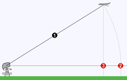
An example of slant range is the distance to an aircraft flying at high altitude with respect to that of the radar antenna. The slant range (1) is the hypotenuse of the triangle represented by the altitude of the aircraft and the distance between the radar antenna and the aircraft's ground track (point (3) on the earth directly below the aircraft). In the absence of altitude information, for example from a height finder, the aircraft location would be plotted further (2) from the antenna than its actual ground track.
Sources and credits
This article is adapted from the Wikipedia article “Slant range”, written by its contributors and licensed under CC BY-SA 4.0. Fathomly has changed the layout, removed citation markers, navigation and maintenance notices, and adjusted punctuation. This adapted version is shared under the same license. For references, see the original article.
Images, from Wikimedia Commons:
- MISB ST 0601.8 - Sensor Slant Range.png by Motion Imagery Standards Board (MISB), Public domain
- Slant range.png by WolfgangW., using pixel grafics from de:Bild:Radaroperation.gif by de:user:Averse, CC BY-SA 3.0
Fathomly is not affiliated with or endorsed by the Wikimedia Foundation. Spotted a problem? Tell us.

