Outline of Mauritius
Island nation in the southwest Indian Ocean

The following outline is provided as an overview of and topical guide to Mauritius:
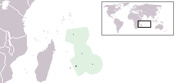
Mauritius , sovereign island nation located in the southwest Indian Ocean about 900 kilometres (560 mi) east of Madagascar. In addition to the Island of Mauritius, the republic includes the islands of St. Brandon, Rodrigues and the Agaléga Islands. Mauritius is part of the Mascarene Islands, with the French island of Réunion 200 km (125 mi) to the southwest and the island of Rodrigues 570 km to the northeast.
01General reference
- Pronunciation:
- Common English country name: Mauritius
- Official English country name: The Republic of Mauritius
- Official endonym (s): Mauritius (English), Maurice (French)
- Common endonym (s): Île Maurice (French), Moris (Mauritian Creole), मॉरिशस (Hindi)
- Adjectival(s): Mauritian
- Demonym(s): Mauritian
- Etymology: Maurice, Prince of Orange
- International rankings of Mauritius
- ISO country codes: MU, MUS, 480
- ISO region codes: See ISO 3166-2:MU
- Internet country code top-level domain: .mu
02Geography of Mauritius
- Mauritius is: an island country
- Location:
- Eastern Hemisphere and Southern Hemisphere
- Africa (off its east coast, east of Madagascar)
- Indian Ocean
- Time zone: Mauritius Time (UTC+04)
- Extreme points of Mauritius
- High: Piton de la Petite Rivière Noire 828 m (2,717 ft)
- Low: Indian Ocean 0 m
- Land boundaries: none
- Coastline: Indian Ocean 177 km
- Population of Mauritius: 1,262,000, 151st most populous country
- Area of Mauritius: 2,040 km2
- Atlas of Mauritius
Environment of Mauritius
- Climate of Mauritius
- Protected areas of Mauritius
- Wildlife of Mauritius
Natural geographic features of Mauritius
- Glaciers in Mauritius: none
- Rivers of Mauritius
- World Heritage Sites in Mauritius
Regions of Mauritius
Regions of Mauritius
Ecoregions of Mauritius
List of ecoregions in Mauritius
Administrative divisions of Mauritius
Districts of Mauritius
- Black River
- Flacq
- Grand Port
- Moka
- Pamplemousses
- Plaines Wilhems
- Port Louis
- Rivière du Rempart
- Savanne
Towns of Mauritius
- Beau-Bassin Rose-Hill
- Curepipe
- Port Louis: Capital of Mauritius
- Quatre Bornes
- Vacoas-Phoenix
Demography of Mauritius

03Government and politics of Mauritius
- Form of government:
- Capital of Mauritius: Port Louis
- Elections in Mauritius
- Political parties in Mauritius
Branches of the government of Mauritius
Executive branch of the government of Mauritius
- Head of state: President of Mauritius, Dharam Gokhool
- Head of government: Prime Minister of Mauritius, Navin Ramgoolam
- Cabinet of Mauritius
Legislative branch of the government of Mauritius
Judicial branch of the government of Mauritius
Court system of Mauritius
Foreign relations of Mauritius
Foreign relations of Mauritius
International organization membership
The Republic of Mauritius is a member of:
Law and order in Mauritius
Law of Mauritius
- Constitution of Mauritius
- Crime in Mauritius
- Human rights in Mauritius
- Law enforcement in Mauritius
Military of Mauritius
- Command
- Forces
Local government in Mauritius
Local government in Mauritius

04History of Mauritius
- Current events of Mauritius

05Culture of Mauritius
- Cuisine of Mauritius
- Languages of Mauritius
- Media of Mauritius
- National symbols of Mauritius
- Newspapers in Mauritius
- Prostitution in Mauritius
- Public holidays in Mauritius
- Religion in Mauritius
- World Heritage Sites in Mauritius
Art in Mauritius
- Since 2009 there is an Opera Festival in Mauritius
Opera Mauritius and The Friends,
Sports in Mauritius
Sports in Mauritius

06Economy and infrastructure of Mauritius
- Economic rank, by nominal GDP (2007): 130th (one hundred and thirtieth)
- Communications in Mauritius
- Companies of Mauritius
- Currency of Mauritius: Rupee
- ISO 4217: MUR
- Health care in Mauritius
- Mining in Mauritius
- Mauritius Stock Exchange
- Sugar industry of Mauritius
- Tourism in Mauritius
- Transport in Mauritius
Sources and credits
This article is adapted from the Wikipedia article “Outline of Mauritius”, written by its contributors and licensed under CC BY-SA 4.0. Fathomly has changed the layout, removed citation markers, navigation and maintenance notices, and adjusted punctuation. This adapted version is shared under the same license. For references, see the original article.
Images, from Wikimedia Commons:
- Flag of Mauritius.svg by Zscout370, Public domain
- LocationMauritius.png by Unknown author, Public domain
- Mauritius Island map-fr.jpg by Eric Gaba (Sting - fr:Sting), CC BY-SA 4.0
- Mauritius Island topographic map-fr.svg by Eric Gaba (Sting - fr:Sting), CC BY-SA 4.0
- L'île Maurice vue par Sentinel 2 (cropped).jpg by European Space Agency / CNES, Attribution
- Mauritius2021OSM.png by Kelisi, CC BY-SA 4.0
Fathomly is not affiliated with or endorsed by the Wikimedia Foundation. Spotted a problem? Tell us.
