Equirectangular projection
Cylindrical equidistant map projection

The equirectangular projection (also called the equidistant cylindrical projection or la carte parallélogrammatique projection), which includes the special cases of the Gall isographic projection and the plate carrée projection (also called the geographic projection, lat/lon projection, or plane chart), is a simple map projection attributed to Marinus of Tyre who, Ptolemy claims, invented the projection about AD 100.
The projection maps meridians to vertical straight lines of constant spacing (for meridional intervals of constant spacing), and circles of latitude to horizontal straight lines of constant spacing (for constant intervals of parallels). The projection is neither equal area nor conformal. Because of the distortions introduced by this projection, it has little use in navigation or cadastral mapping and finds its main use in thematic mapping. In particular, the plate carrée has become a standard for global raster datasets, such as Celestia, NASA World Wind, the USGS Astrogeology Research Program, and Natural Earth, because of the particularly simple relationship between the position of an image pixel on the map and its corresponding geographic location on Earth or other spherical solar system bodies. In addition it is frequently used in panoramic photography to represent a spherical panoramic image.
01Definition
The forward projection transforms spherical coordinates into planar coordinates. The reverse projection transforms from the plane back onto the sphere. The formulae presume a spherical model and use these definitions:
is the longitude of the location to project;
is the latitude of the location to project;
are the standard parallels (north and south of the equator) where the scale of the projection is true;
is the central parallel of the map;
is the central meridian of the map;
is the horizontal coordinate of the projected location on the map;
is the vertical coordinate of the projected location on the map;
is the radius of the globe.
Longitude and latitude variables are defined here in terms of radians.
Forward
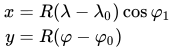
The plate carrée (French, for flat square), is the special case where
When the 


While a projection with equally spaced parallels is possible for an ellipsoidal model, it would no longer be equidistant because the distance between parallels on an ellipsoid is not constant. More complex formulae can be used to create an equidistant map whose parallels reflect the true spacing.
Reverse
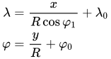
Alternative names
In spherical panorama viewers, usually:
where both are defined in degrees.


Sources and credits
This article is adapted from the Wikipedia article “Equirectangular projection”, written by its contributors and licensed under CC BY-SA 4.0. Fathomly has changed the layout, removed citation markers, navigation and maintenance notices, and adjusted punctuation. This adapted version is shared under the same license. For references, see the original article.
Images, from Wikimedia Commons:
- Equirectangular projection SW.jpg by Strebe, CC BY-SA 3.0
- Blue Marble 2002.png by NASA’s Terra satellite for the MODIS imageries, combined by Meow. Credit: NASA Goddard Space Flight Center Image by Reto Stöckli (land surface, shallow water, clouds). Enhancements by Robert Simmon (ocean color, compositing, 3D globes, animation). Data and technical support: MODIS Land Group; MODIS Science Data Support Team; MODIS Atmosphere Group; MODIS Ocean Group Additional data: USGS EROS Data Center (topography); USGS Terrestrial Remote Sensing Flagstaff Field Center (Antarctica); Defense Meteorological Satellite Program (city lights)., Public domain
- Plate Carrée with Tissot's Indicatrices of Distortion.svg by Justin Kunimune, CC BY-SA 4.0
- World elevation map.png by Avsa, CC BY-SA 4.0
Fathomly is not affiliated with or endorsed by the Wikimedia Foundation. Spotted a problem? Tell us.


