Dead reckoning
Means of calculating position

In navigation, dead reckoning is the process of calculating the current position of a moving object by using a previously determined position, or fix, and incorporating estimates of speed, heading (or direction or course), and elapsed time. The corresponding term in biology, to describe the processes by which animals update their estimates of position or heading, is path integration.
Advances in navigational aids that give accurate information on position, in particular satellite navigation using the Global Positioning System, have made simple dead reckoning by humans obsolete for most purposes. However, inertial navigation systems, which provide very accurate directional information, use dead reckoning and are very widely applied.
01Etymology
Contrary to myth, the term "dead reckoning" was not originally used to abbreviate "deduced reckoning", nor is it a misspelling of the term "ded reckoning". The use of "ded" or "deduced reckoning" is not known to have appeared earlier than 1931, much later in history than "dead reckoning", which appeared as early as 1613 according to the Oxford English Dictionary. The original intention of "dead" in the term is generally assumed to mean using a stationary object that is "dead in the water" as a basis for calculations. Additionally, at the time the first appearance of "dead reckoning", "ded" was considered a common spelling of "dead". This potentially led to later confusion of the origin of the term.
By analogy with their navigational use, the words dead reckoning are also used to mean the process of estimating the value of any variable quantity by using an earlier value and adding whatever changes have occurred in the meantime. Often, this usage implies that the changes are not known accurately. The earlier value and the changes may be measured or calculated quantities.

02Errors
While dead reckoning can give the best available information on the present position with little math or analysis, it is subject to significant errors of approximation. For precise positional information, both speed and direction must be accurately known at all times during travel. Most notably, dead reckoning does not account for directional drift during travel through a fluid medium. These errors tend to compound themselves over greater distances, making dead reckoning a difficult method of navigation for longer journeys.
For example, if displacement is measured by the number of rotations of a wheel, any discrepancy between the actual and assumed traveled distance per rotation, due perhaps to slippage or surface irregularities, will be a source of error. As each estimate of position is relative to the previous one, errors are cumulative, or compounding, over time.
The accuracy of dead reckoning can be increased significantly by using other, more reliable methods to get a new fix part way through the journey. For example, if one was navigating on land in poor visibility, then dead reckoning could be used to get close enough to the known position of a landmark to be able to see it, before walking to the landmark itself, giving a precisely known starting point, and then setting off again.
03Localization of mobile sensor nodes
Localizing a static sensor node is not a difficult task because attaching a Global Positioning System (GPS) device suffices the need of localization. But a mobile sensor node, which continuously changes its geographical location with time is difficult to localize. Mostly mobile sensor nodes within some particular domain for data collection can be used, i.e, sensor node attached to an animal within a grazing field or attached to a soldier on a battlefield. Within these scenarios a GPS device for each sensor node cannot be afforded. Some of the reasons for this include cost, size and battery drainage of constrained sensor nodes. To overcome this problem a limited number of reference nodes (with GPS) within a field is employed. These nodes continuously broadcast their locations and other nodes in proximity receive these locations and calculate their position using some mathematical technique like trilateration. For localization, at least three known reference locations are necessary to localize. Several localization algorithms based on Sequential Monte Carlo (SMC) method have been proposed in literature. Sometimes a node at some places receives only two known locations and hence it becomes impossible to localize. To overcome this problem, dead reckoning technique is used. With this technique a sensor node uses its previous calculated location for localization at later time intervals. For example, at time instant 1 if node A calculates its position as loca_1 with the help of three known reference locations; then at time instant 2 it uses loca_1 along with two other reference locations received from other two reference nodes. This not only localizes a node in less time but also localizes in positions where it is difficult to get three reference locations.
04Animal navigation
In studies of animal navigation, dead reckoning is more commonly (though not exclusively) known as path integration. Animals use it to estimate their current location based on their movements from their last known location. Animals such as ants, rodents, and geese have been shown to track their locations continuously relative to a starting point and to return to it, an important skill for foragers with a fixed home.

07Pedestrian dead reckoning
With the increased sensor offering in smartphones, built-in accelerometers can be used as a pedometer and built-in magnetometer as a compass heading provider. Pedestrian dead reckoning (PDR) can be used to supplement other navigation methods in a similar way to automotive navigation, or to extend navigation into areas where other navigation systems are unavailable.
In a simple implementation, the user holds their phone in front of them, and each step causes their position to move forward a fixed distance in the direction measured by the compass. Accuracy is limited by the sensor precision, magnetic disturbances inside structures, and unknown variables such as carrying position and stride length. Another challenge is differentiating walking from running, and recognizing movements like bicycling, climbing stairs, or riding an elevator.
Before phone-based systems existed, many custom PDR systems existed. While a pedometer can only be used to measure linear distance traveled, PDR systems have an embedded magnetometer for heading measurement. Custom PDR systems can take many forms including special boots, belts, and watches, where the variability of carrying position has been minimized to better utilize magnetometer heading. True dead reckoning is fairly complicated, as it is not only important to minimize basic drift, but also to handle different carrying scenarios and movements, as well as hardware differences across phone models.

08Directional dead reckoning
The south-pointing chariot was an ancient Chinese device consisting of a two-wheeled horse-drawn vehicle which carried a pointer that was intended always to aim to the south, no matter how the chariot turned. The chariot pre-dated the navigational use of the magnetic compass, and could not detect the direction that was south. Instead it used a kind of directional dead reckoning: at the start of a journey, the pointer was aimed southward by hand, using local knowledge or astronomical observations e.g. of the Pole Star. Then, as it traveled, a mechanism possibly containing differential gears used the different rotational speeds of the two wheels to turn the pointer relative to the body of the chariot by the angle of turns made (subject to available mechanical accuracy), keeping the pointer aiming in its original direction, to the south. Errors, as always with dead reckoning, would accumulate as distance traveled increased.
09For networked games
Networked games and simulation tools routinely use dead reckoning to predict where an actor should be right now, using its last known kinematic state (position, velocity, acceleration, orientation, and angular velocity). This is primarily needed because it is impractical to send network updates at the rate that most games run, 60 Hz. The basic solution starts by projecting into the future using linear physics:
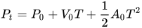
This formula is used to move the object until a new update is received over the network. At that point, the problem is that there are now two kinematic states: the currently estimated position and the just received, actual position. Resolving these two states in a believable way can be quite complex. One approach is to create a curve (e.g. cubic Bézier splines, centripetal Catmull-Rom splines, and Hermite curves) between the two states while still projecting into the future. Another technique is to use projective velocity blending, which is the blending of two projections (last known and current) where the current projection uses a blending between the last known and current velocity over a set time.
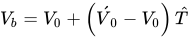



The first equation calculates a blended velocity 


Next, two positions are calculated: firstly, the blended velocity 


Finally, the new position to display on the client 
Sources and credits
This article is adapted from the Wikipedia article “Dead reckoning”, written by its contributors and licensed under CC BY-SA 4.0. Fathomly has changed the layout, removed citation markers, navigation and maintenance notices, and adjusted punctuation. This adapted version is shared under the same license. For references, see the original article.
Images, from Wikimedia Commons:
- Dead-reckoning colour.svg by Belbury, CC0
- Wind drift.png by Abuk SABUK, CC BY-SA 3.0
- CYA Coastal Navigation With Dead Reckoning 2.jpg by J. S. Bond, CC BY-SA 3.0
- RCAF DR Nav Tools 1940.JPG by J.S.Bond, CC BY-SA 3.0
Fathomly is not affiliated with or endorsed by the Wikimedia Foundation. Spotted a problem? Tell us.


